What to do if you lose phone coverage at sea: offline charts and maps
As soon as you move away from the coast, mobile coverage becomes unreliable. GPS does not fail, because it needs no data. What fails is everything that comes from a server: the map, the forecast, the alert. The answer is to prepare the trip with the network, not depend on it.
What keeps working without coverage
- The phone's GPS. A phone computes its position from satellites. It needs neither mobile data nor wifi. Without data your dot keeps moving, but over a map that may not have loaded.
- What is already inside the app. In Embarca, the detailed chart of the Spanish coasts is inside the app itself. The distance to the coast and your 2-mile line are computed on the phone, with no network.
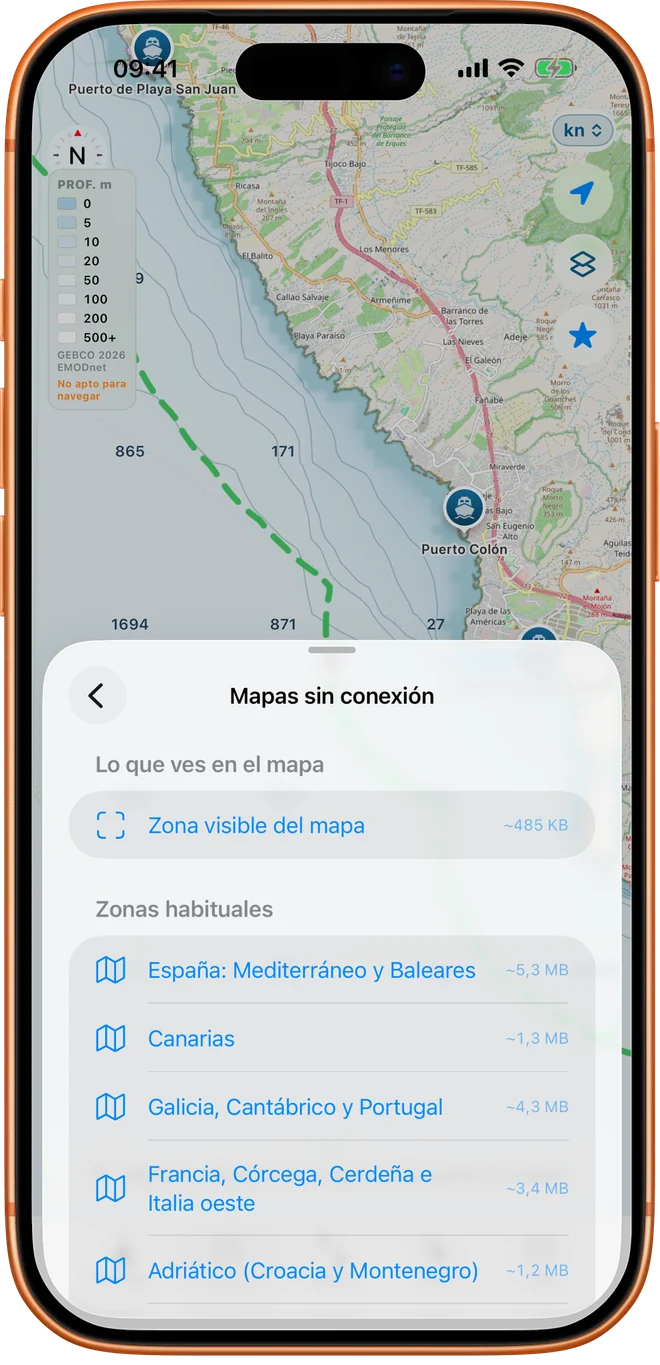
- What you downloaded. With Pro you can download whole areas before leaving.
What stops working
- The base map of streets and coast if you had not viewed it before: OpenStreetMap maps cannot be bulk-downloaded under its servers' usage policy. Embarca caches what you saw while online. In an area you never saw with coverage, offline you see the depth shading, contours and the 2-mile line over an empty background; the shape of the coast can be read from the edge of the shading.
- The weather forecast and its updates.
- Downloading other boaters' routes and anything that needs the server.
- The distress SMS, if there is no phone coverage. An SMS needs mobile network, though not data: with no coverage at all it does not go.
The preparation routine (two minutes, at home, on wifi)
- Download the area where you will move: in Embarca, in the offline maps section. You choose a preset area or the visible part of the map; before downloading it shows the estimated size (a few megabytes in the areas tested).
- Browse the map at different zooms of the area while online: that stores it in the app cache, background included.
- Check the day's forecast (and take a screenshot): without a network you cannot refresh it.
- Try airplane mode for a few seconds with the app open: if you see your position and the map, you are ready.
- Share your plan with someone: how to tell someone your return time.
Look after the battery
GPS on screen drains the battery. Lower the brightness as far as is comfortable, do not leave the screen on when you do not need it, use battery saver and carry a power bank and its cable in a waterproof bag. A dead phone is a phone without GPS and without SOS.
A plan B that does not depend on the phone
- VHF. A handheld radio with channel 16 reaches where the phone does not. Salvamento Marítimo centres monitor channel 16 permanently. Salvamento notes that the distress contacts are in any case: 900 202 202, 112 and channel 16.
- Paper. A chart or sketch of the area in a waterproof sleeve, and a compass. They weigh little and never run out of battery.
- Flares and a whistle to attract attention when you are within sight of the coast or other boats.
- Your recorded track. If you lose your bearings, the logbook shows you where you came from.
What Embarca does with a route when coverage goes
If you share your route live, the app stores your position while there is no signal and sends it when it returns. The link you shared shows the viewer when the last data point arrived, so they can tell how long you have been out of coverage. The logbook stores each trip on the phone, even if it switches off.
A case: the cove with no signal
Example scenario.
Lucía is going to a cove that never has coverage. On Thursday, at home on wifi, she downloads the whole area with Pro: depth and coastline. On Sunday, halfway there, the phone loses data. In Navigate her dot keeps moving over the chart, with the distance to the coast and her 2-mile line. What she downloaded keeps working, even if one day she stops having Pro. And because before leaving she told her partner where she was going and when she would be back, nobody worries.
Sources
- Salvamento Marítimo, distress calls (112, 900 202 202, VHF channel 16, channel 70 and 2,187 kHz DSC; in Spanish). Checked on 14 October 2026.
- Salvamento Marítimo, weather information (VHF, NAVTEX).
- OpenStreetMap copyright and use and its tile usage policy.