A trip from Caleta de Vélez to Maro, with photos, in the logbook
A logbook does two things: it helps you remember what you did and lets you show it to someone. On an inflatable almost nobody carries a soggy notebook in a pocket, but everybody carries a phone. This is the story of a trip from Caleta de Vélez to Maro, as it ends up in Embarca.
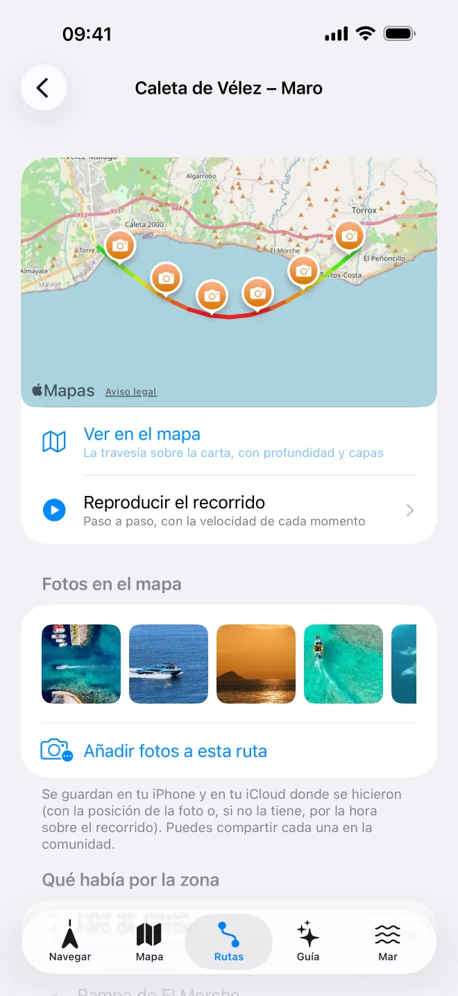
A clarification before we go on. The screenshot in this article is a demo trip with sample photos, not a real outing by anyone. It is there to show what the app keeps and how it looks.
The outing
Picture a summer Saturday. You leave in the morning from Caleta de Vélez, in Vélez-Málaga, with the inflatable loaded with just what you need (if you are not sure what that is, here is the list), and the plan is to follow the coast east, pass Torrox and reach Maro, in Nerja, where the cliffs drop almost straight into the water. Before casting off you have checked the weather (levante, poniente and when to go) and pressed record.
That is all you have to do. Embarca keeps saving your position while you sail, so the phone can stay in its waterproof case while you get on with it: driving, looking, swimming.
Photos, in their place
Through the morning you take photos the way you always do: the wake of the inflatable, a fishing boat, the sun on the water, a fin in the distance. Back on land, the trip page has "Photos on the map": you pick the ones you want and Embarca places them on the track, using the photo's own position or, if it has none, the time you took it, working out where you were at that moment.
The result is what you see here: a line from one end of the coast to the other with photos pinned along it. A photo with no place gets forgotten; a photo in its place becomes a memory you can find again.
What you can do with the trip
- See it on the map. "View on the map" opens the trip over the chart, with depth and layers. Handy for seeing, say, what the bottom was like where you stopped.
- Replay the route. Step by step, with the speed at each moment. Useful to understand how long each leg took and where you slowed down.
- What was nearby. The page shows what lies close to the track, such as ramps or points of interest.
- Share with the community. Each photo can be shared, and so can the whole route. How it works, and how your mooring is protected, is in community routes.
Where it is kept
Photos are stored on your iPhone and in your iCloud, where you took them. If your phone breaks or you change it, your logbook does not go with it. When a trip is published to the community, photos are uploaded without metadata and the first and last 300 metres of the track are trimmed on your phone before sending, so nobody knows where you moor.
Free and Pro
- Free: the logbook keeps your 3 latest trips. To record a fourth you have to delete one of the earlier ones first; Embarca asks you and never deletes anything without your confirmation. And if you head out without having chosen, the trip is recorded anyway and you choose when you finish.
- Pro: an unlimited logbook, statistics, GPX export and photos on the trip. The Pro trial lasts 3 outings, enough to do one like this. One-time purchase, no subscription: all in the table on the home page.
A note of caution
That coast has protected stretches, such as the Acantilados de Maro-Cerro Gordo natural area. Before anchoring or diving nearby, check the rules that apply, and remember that your licence has a limit on distance from the coast. Embarca's line only informs: you are the one responsible for sailing safely.